Now 5087 visitors
Today:0 Yesterday:0
Total: 147102
212S 50P 4R
2026-10-20, Week 43 |
| Member Login |
| TACT Journal Homepage |
| Call for Paper |
| Committee |
| Find My Paper |
| Author Homepage |
| Statistics & History |
| Welcome Message |
| Paper Procedure |
| FAQ |
| Paper Archives |
| Outstanding Papers |
| Author Homepage |
| - Paper Procedure |
| - Journal Procedure |
| - Presentation Tips |
|
| Program & Proceedings |
| Program with Papers |
| Plenary Session |
| Tutorial Session |
|
| Presentation Platform |
| Hotel & Travel Info |
| About Korea |
| Accommodation |
| Transportation |
| VISA |
| Other Infomation |
|
| Photo Gallery |
| Scheduler Login |
| Seminar |
| Archives Login |
|
| Sponsors |

|

|

|

|

|

|

|

|

|

|
|
|
|
|
 ICACT20260278 Slide.01
[Big Slide]
[YouTube] |
Chrome  Click!! |
 |
Good morning, ladies and gentlemen. My name is Tran Thi Thanh from Viettel High Technology and Industries Corporation. It is a pleasure to present our work at ICACT 2026. The title of this presentation is “Evaluation of Elevation Angle Representation Methods for Clustered Detections in Multi-Beam Radar.” |
| ICACT20260278 Slide.02
[Big Slide]
|
Chrome Click!! |
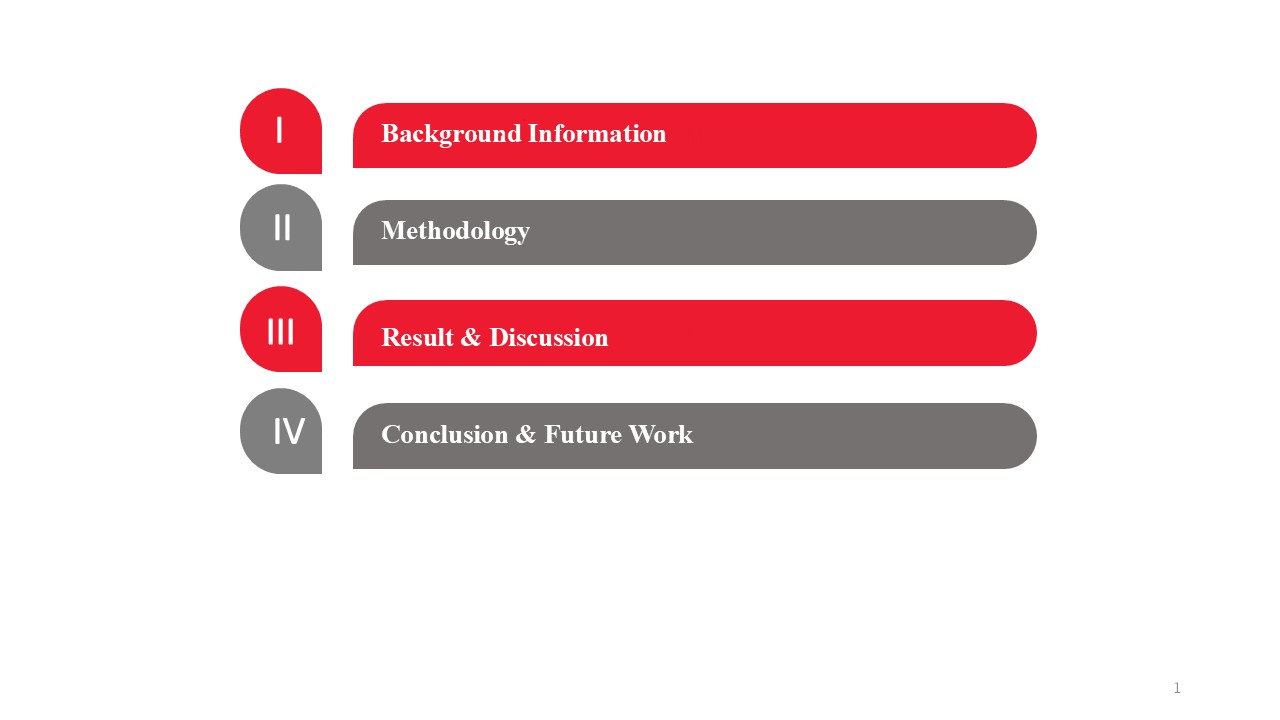 |
This presentation is organized into four main parts. Firstly, I will provide some background information and introduce the research motivation. Secondly, I will describe the methodology, including the system overview and the elevation angle representation methods considered in this study. Thirdly, I will present the results and discussion, where the performance of different methods is evaluated and compared. Finally, I will conclude the presentation and briefly discuss future work.
Let us begin with the background information. |
| ICACT20260278 Slide.03
[Big Slide]
|
Chrome Click!! |
 |
Let start with the first part: background information |
| ICACT20260278 Slide.04
[Big Slide]
|
Chrome Click!! |
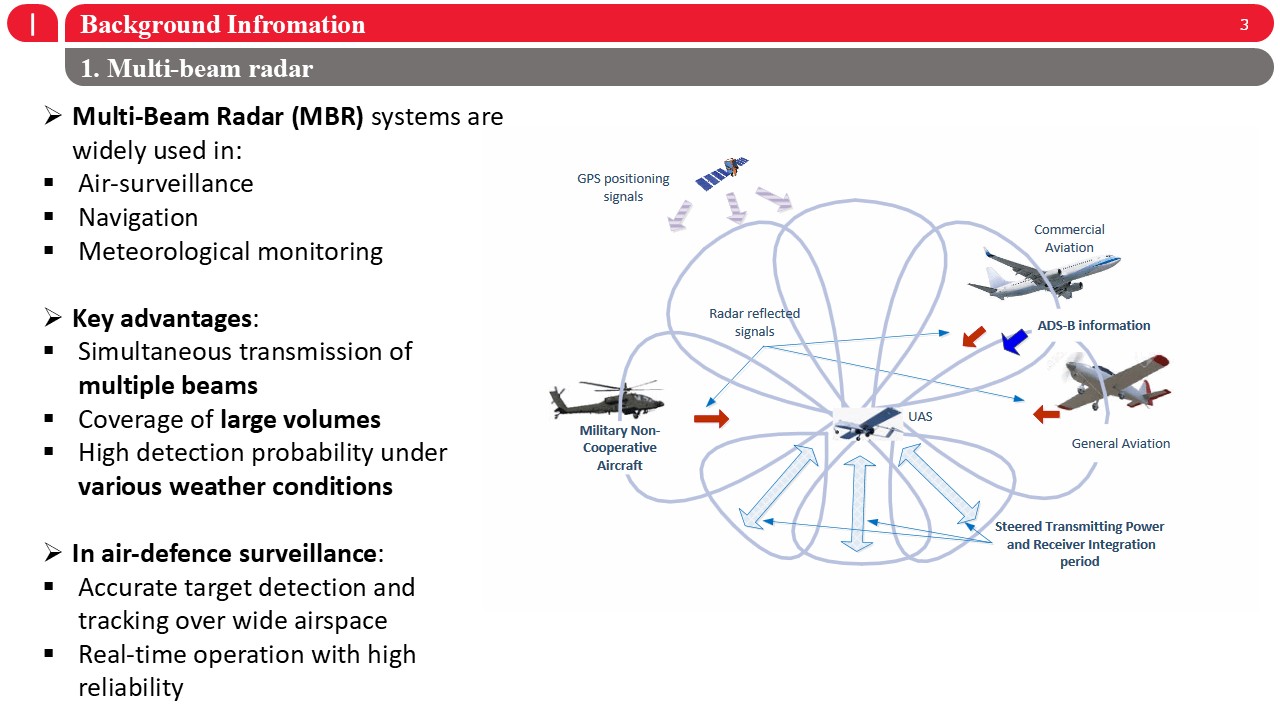 |
Let me first introduce the background of multi-beam radar. Multi-Beam Radar (MBR) systems are widely used in air surveillance, navigation, and meteorological monitoring due to their ability to observe large airspace efficiently. One key advantage of MBR is the simultaneous transmission and reception of multiple beams, which enables wide coverage, faster scanning, and high detection probability, even under challenging weather conditions. In air-defence surveillance, multi-beam radar provides accurate target detection and tracking over a wide area, while supporting real-time operation with high reliability. These characteristics make MBR an essential technology for modern radar systems and also introduce challenges in processing and representing elevation information, which motivates our study. |
| ICACT20260278 Slide.05
[Big Slide]
|
Chrome Click!! |
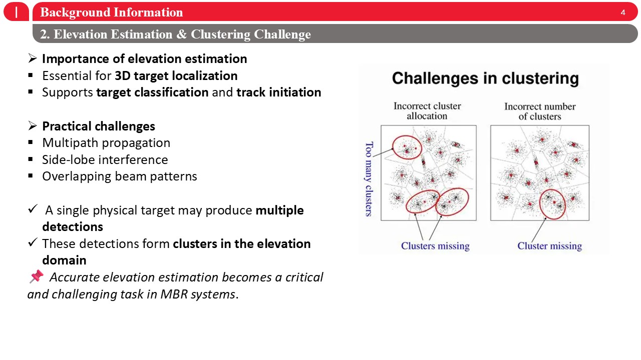 |
Next, I would like to highlight the importance of elevation estimation and the associated clustering challenges. Accurate elevation estimation is essential for 3D target localization and plays a key role in target classification and track initiation in multi-beam radar systems. However, in practical environments, several challenges arise, including multipath propagation, side-lobe interference, and overlapping beam patterns. As a result, a single physical target may generate multiple radar detections, which form clusters in the elevation domain rather than a single measurement. These clustered detections make elevation estimation more complex, and incorrect clustering may lead to missing targets or incorrect track formation. Therefore, accurate and robust elevation angle representation becomes a critical and challenging task in multi-beam radar systems, which is the main motivation of this work. |
| ICACT20260278 Slide.06
[Big Slide]
|
Chrome Click!! |
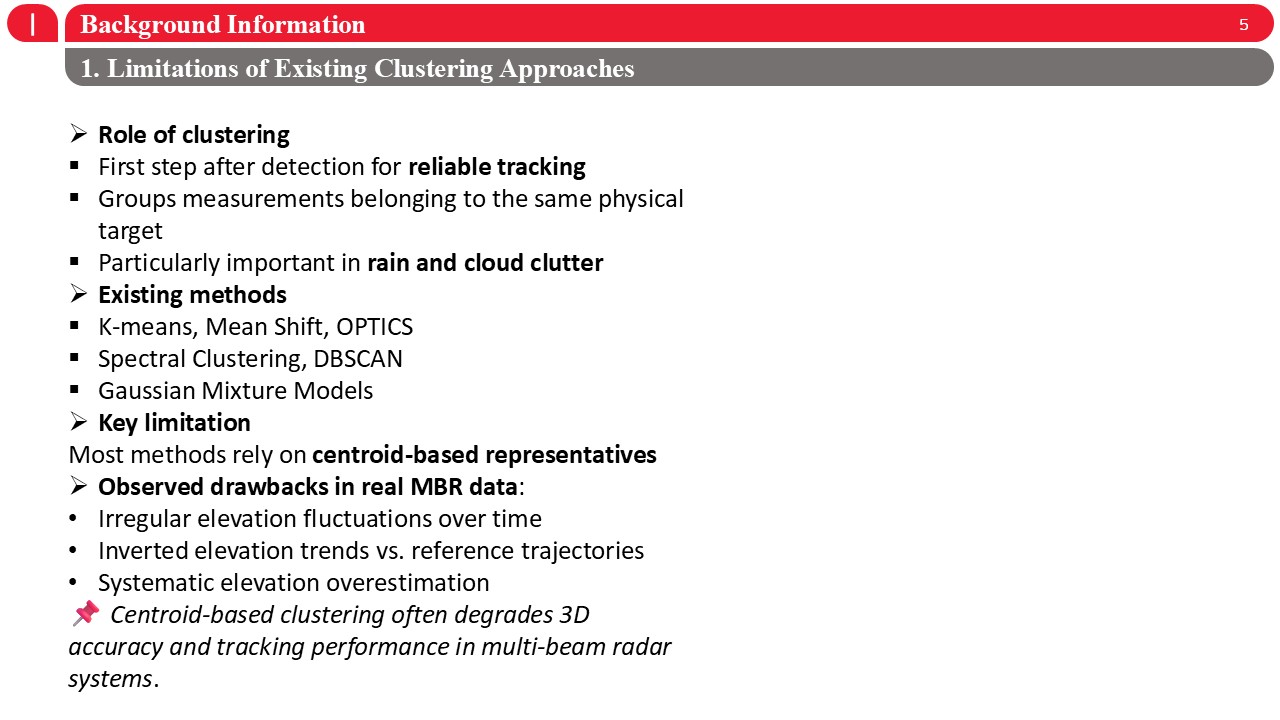 |
Next, I will briefly discuss the limitations of existing clustering approaches. In multi-beam radar systems, clustering is a critical step after detection, as it groups measurements belonging to the same physical target and directly affects tracking reliability, especially in rain and cloud clutter environments. Commonly used clustering methods include K-means, Mean Shift, OPTICS, spectral clustering, DBSCAN, and Gaussian mixture models. However, most of these methods rely on centroid-based representations to describe clustered detections. In real multi-beam radar data, this assumption often leads to several drawbacks, such as irregular elevation fluctuations over time, inverted elevation trends compared to reference trajectories, and systematic elevation overestimation. As a result, centroid-based clustering can significantly degrade 3D localization accuracy and overall tracking performance in multi-beam radar systems. |
| ICACT20260278 Slide.07
[Big Slide]
|
Chrome Click!! |
 |
Secondly, i will present our methodology. |
| ICACT20260278 Slide.08
[Big Slide]
|
Chrome Click!! |
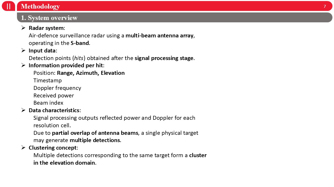 |
Now I will introduce the system overview used in this study. The radar system considered is an air-defence surveillance radar equipped with a multi-beam antenna array, operating in the S-band. The input data consists of detection points, or hits, obtained after the radar signal processing stage. Each detection provides several types of information, including range, azimuth, elevation, timestamp, Doppler frequency, received power, and the corresponding beam index. Due to the partial overlap of antenna beams, a single physical target may generate multiple detections across different elevation beams. Therefore, detections corresponding to the same target naturally form a cluster in the elevation domain, which motivates the elevation angle representation and clustering methods discussed in this work. |
| ICACT20260278 Slide.09
[Big Slide]
|
Chrome Click!! |
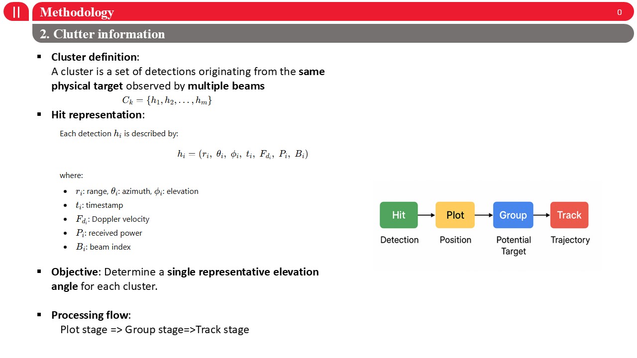 |
Next, I will explain how cluster information is defined and represented in this work. A cluster is defined as a set of detections originating from the same physical target, observed by multiple radar beams. Each detection, or hit, is represented by a feature vector that includes range, azimuth, elevation, timestamp, Doppler velocity, received power, and the beam index. Our objective is to determine a single representative elevation angle for each cluster, which can be used reliably in subsequent tracking stages. In terms of processing flow, detections are first plotted, then grouped into clusters, and finally passed to the tracking stage to form target trajectories. This cluster representation forms the basis for evaluating different elevation angle representation methods in our study. |
| ICACT20260278 Slide.10
[Big Slide]
|
Chrome Click!! |
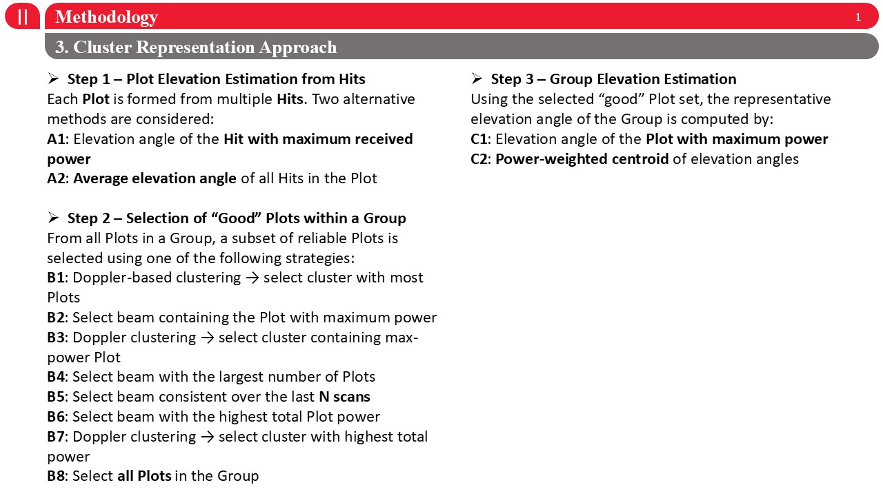 |
Next, I will explain the proposed cluster representation approach, which consists of three main steps. Step one is plot-level elevation estimation. Each plot is formed from multiple hits, and we consider two alternatives: first, using the elevation angle of the hit with maximum received power, and second, using the average elevation angle of all hits within the plot. Step two focuses on the selection of reliable, or “good,” plots within a group. From all plots in a group, a subset is selected using different strategies based on Doppler clustering, beam index, power level, temporal consistency, or combinations of these criteria. Step three is group-level elevation estimation. Using the selected good plots, the representative elevation angle of the group is computed either as the elevation angle of the plot with maximum power, or as a power-weighted centroid of elevation angles. This three-step framework allows us to systematically evaluate how different plot and group representation choices affect elevation accuracy and tracking performance. |
| ICACT20260278 Slide.11
[Big Slide]
|
Chrome Click!! |
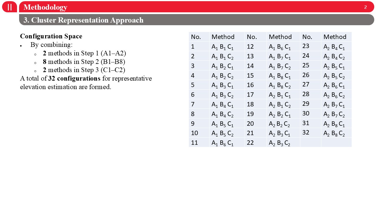 |
Based on the three-step cluster representation framework, we construct a comprehensive configuration space.
Specifically, we combine two methods for plot-level elevation estimation in Step one, eight strategies for selecting reliable plots in Step two, and two methods for group-level elevation estimation in Step three. This results in a total of 32 different configurations for representative elevation angle estimation. Each configuration corresponds to a unique combination of plot estimation, plot selection, and group representation, as summarized in the table on the right. These configurations are systematically evaluated to analyze their impact on elevation accuracy and tracking performance. |
| ICACT20260278 Slide.12
[Big Slide]
|
Chrome Click!! |
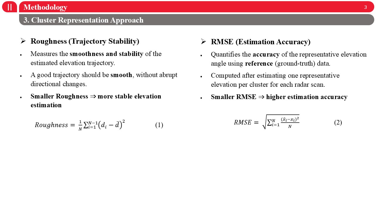 |
To evaluate the cluster representation approach, we use two complementary metrics: roughness and RMSE.Roughness measures the smoothness and stability of the estimated elevation trajectory over time. A stable trajectory should be smooth, without abrupt directional changes. Therefore, a smaller roughness value indicates more stable elevation estimation.RMSE, on the other hand, quantifies estimation accuracy by comparing the representative elevation angle with ground-truth reference data. It is computed after estimating one representative elevation per cluster for each radar scan.In this case, a smaller RMSE corresponds to higher estimation accuracy. |
| ICACT20260278 Slide.13
[Big Slide]
|
Chrome Click!! |
 |
Now i will show you the result and discussion. |
| ICACT20260278 Slide.14
[Big Slide]
|
Chrome Click!! |
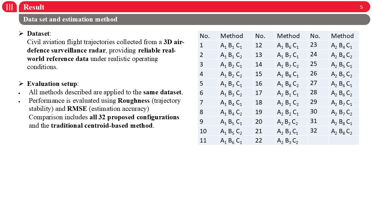 |
For performance evaluation, we use real civil aviation flight trajectories collected from a 3D air-defence surveillance radar. This dataset provides reliable real-world reference data under realistic operating conditions.All proposed methods are applied to the same dataset to ensure a fair comparison. Performance is evaluated using two metrics: Roughness, which measures trajectory stability, and RMSE, which measures estimation accuracy.The comparison includes all 32 proposed configurations, as well as the traditional centroid-based method as a baseline. |
| ICACT20260278 Slide.15
[Big Slide]
|
Chrome Click!! |
 |
For performance evaluation, we use real civil aviation flight trajectories collected from a 3D air-defence surveillance radar. This dataset provides reliable real-world reference data under realistic operating conditions.All proposed methods are applied to the same dataset to ensure a fair comparison. Performance is evaluated using two metrics: Roughness, which measures trajectory stability, and RMSE, which measures estimation accuracy.The comparison includes all 32 proposed configurations, as well as the traditional centroid-based method as a baseline. |
| ICACT20260278 Slide.16
[Big Slide]
|
Chrome Click!! |
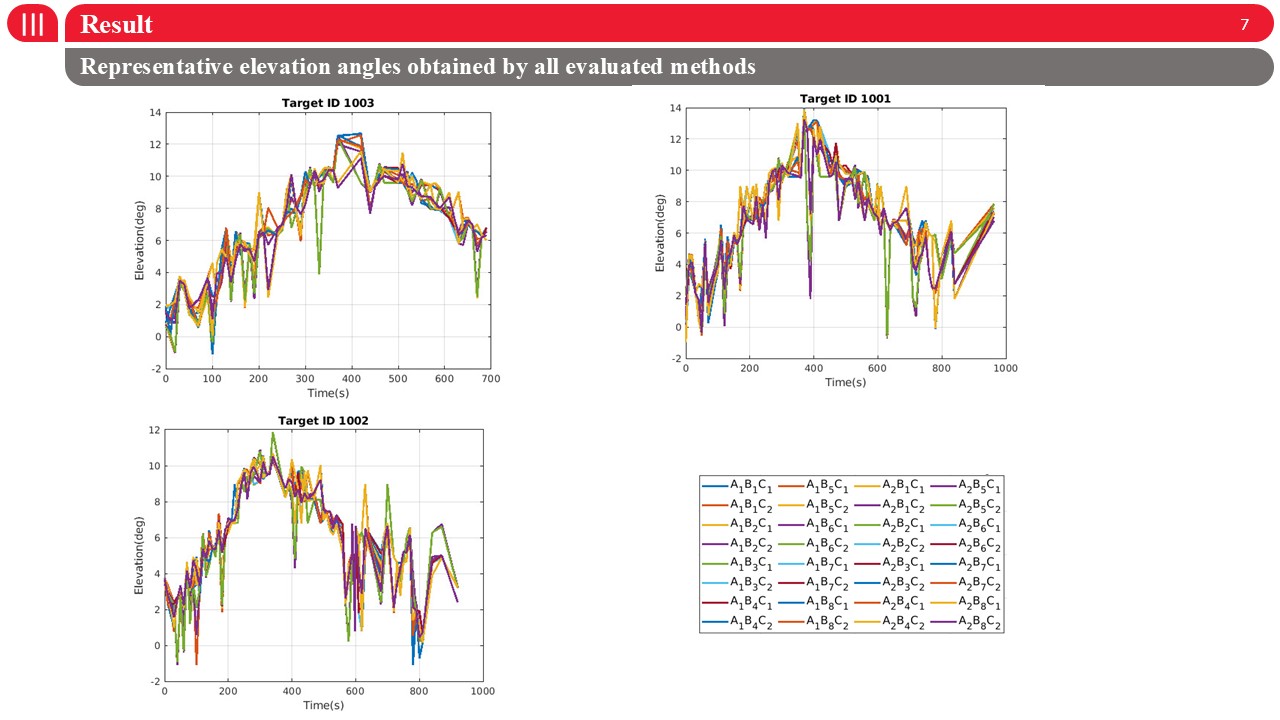 |
This figure shows the representative elevation angle trajectories obtained by all evaluated methods for three different targets.Overall, all methods capture the general elevation trend; however, noticeable differences appear in trajectory smoothness and stability.Some configurations exhibit abrupt fluctuations and spikes, especially during maneuvering phases, while the proposed best method produces a smoother and more consistent elevation trajectory.These visual results are consistent with the quantitative analysis, confirming that the proposed cluster representation improves both estimation stability and accuracy. |
| ICACT20260278 Slide.17
[Big Slide]
|
Chrome Click!! |
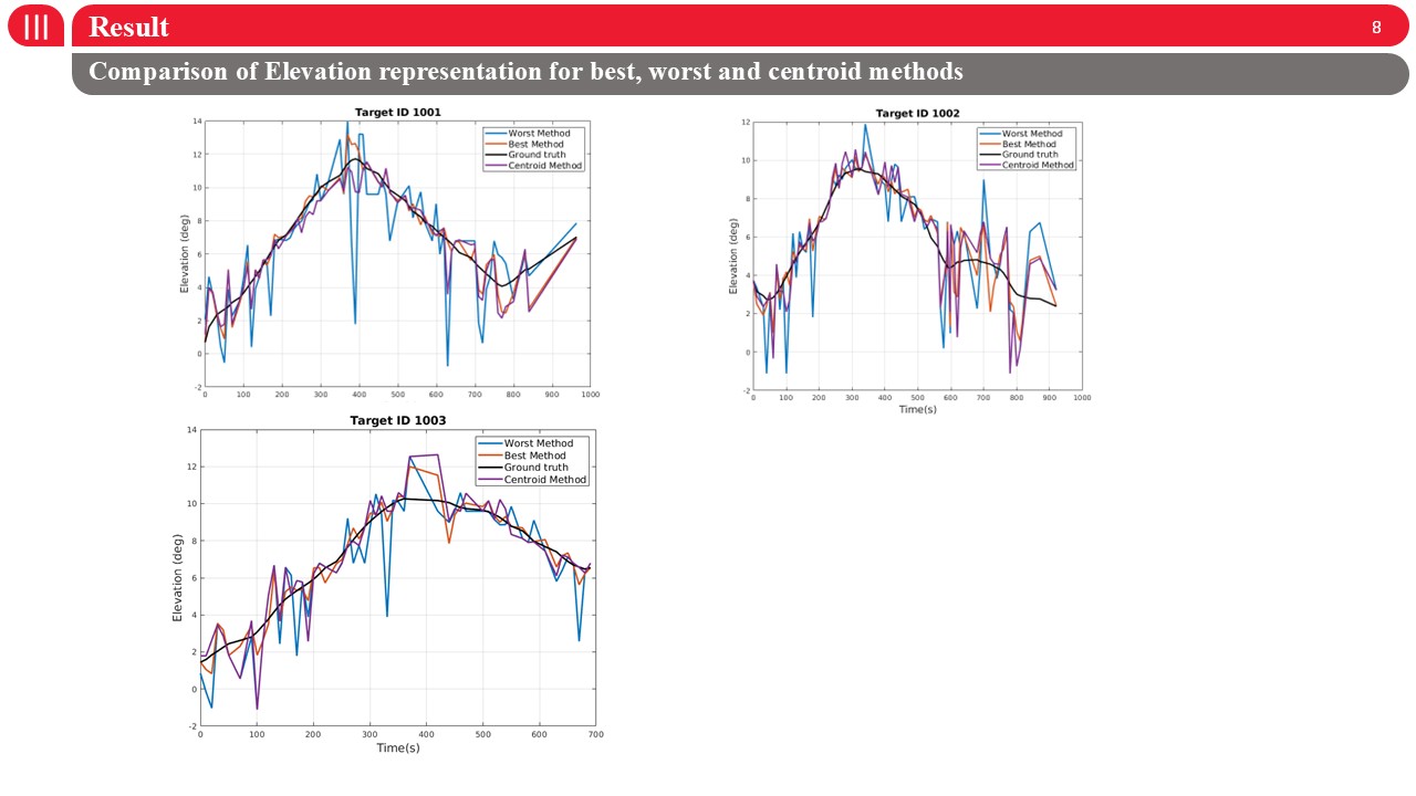 |
This figure compares the elevation angle estimation obtained by the best proposed method, the traditional centroid method, and the worst configuration, against the ground truth for three targets.We observe that the worst method exhibits significant fluctuations and large deviations from the reference, especially during dynamic phases.The centroid-based method improves stability but still shows noticeable bias and tracking delay.In contrast, the proposed best method closely follows the ground truth, providing both smoother trajectories and higher accuracy across all targets.This visual comparison clearly confirms the quantitative RMSE and roughness improvements. |
| ICACT20260278 Slide.18
[Big Slide]
|
Chrome Click!! |
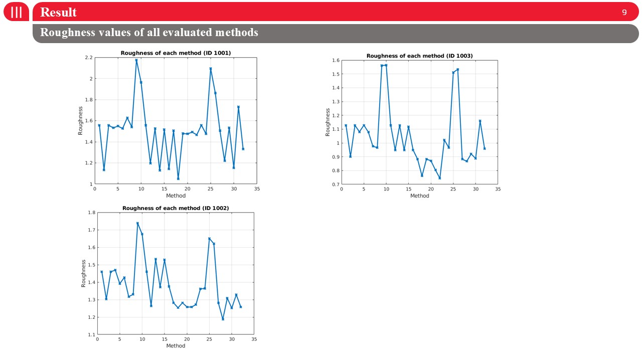 |
This figure shows the roughness values obtained by all evaluated methods for three different targets.Each point corresponds to one of the 32 configurations, where lower values indicate smoother and more stable elevation trajectories.We observe that roughness varies significantly across methods, confirming that the choice of plot selection and representation strategy strongly affects trajectory stability.The best-performing configurations consistently achieve lower roughness across all targets, while several methods exhibit large fluctuations, indicating unstable elevation estimation.These results further support the robustness of the proposed approach. |
| ICACT20260278 Slide.19
[Big Slide]
|
Chrome Click!! |
 |
Finally, i will give you the conclusion. |
| ICACT20260278 Slide.20
[Big Slide]
|
Chrome Click!! |
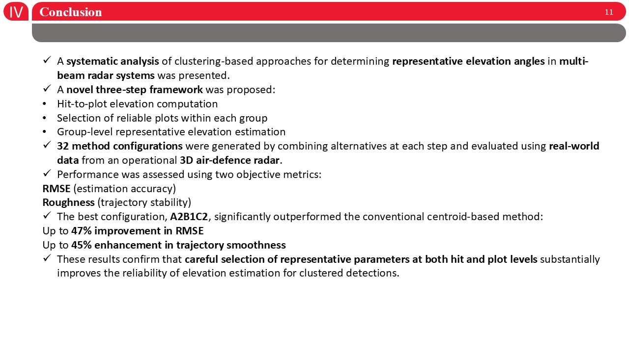 |
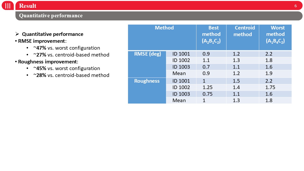
In this work, we presented a systematic analysis of clustering-based methods for estimating representative elevation angles in multi-beam radar systems.A novel three-step framework was proposed, covering hit-level elevation estimation, reliable plot selection, and group-level representation.By combining different strategies at each step, 32 method configurations were evaluated using real-world data from an operational 3D air-defence radar.Performance was assessed using RMSE and roughness, representing accuracy and trajectory stability.The best configuration, A2B1C2, significantly outperformed the conventional centroid-based method, achieving up to 47% RMSE reduction and 45% improvement in smoothness.These results demonstrate that careful selection at both hit and plot levels is critical for reliable elevation estimation. |
| ICACT20260278 Slide.21
[Big Slide]
[YouTube] |
Chrome Click!! |
 |
Thank you for your listening! |
| |