Now 5061 visitors
Today:0 Yesterday:0
Total: 147058
212S 50P 4R
2026-10-20, Week 43 |
| Member Login |
| TACT Journal Homepage |
| Call for Paper |
| Committee |
| Find My Paper |
| Author Homepage |
| Statistics & History |
| Welcome Message |
| Paper Procedure |
| FAQ |
| Paper Archives |
| Outstanding Papers |
| Author Homepage |
| - Paper Procedure |
| - Journal Procedure |
| - Presentation Tips |
|
| Program & Proceedings |
| Program with Papers |
| Plenary Session |
| Tutorial Session |
|
| Presentation Platform |
| Hotel & Travel Info |
| About Korea |
| Accommodation |
| Transportation |
| VISA |
| Other Infomation |
|
| Photo Gallery |
| Scheduler Login |
| Seminar |
| Archives Login |
|
| Sponsors |

|

|

|

|

|
|

|

|

|

|
|
|
|
|
 ICACT20260340 Slide.01
[Big Slide]
[YouTube] |
Chrome  Click!! |
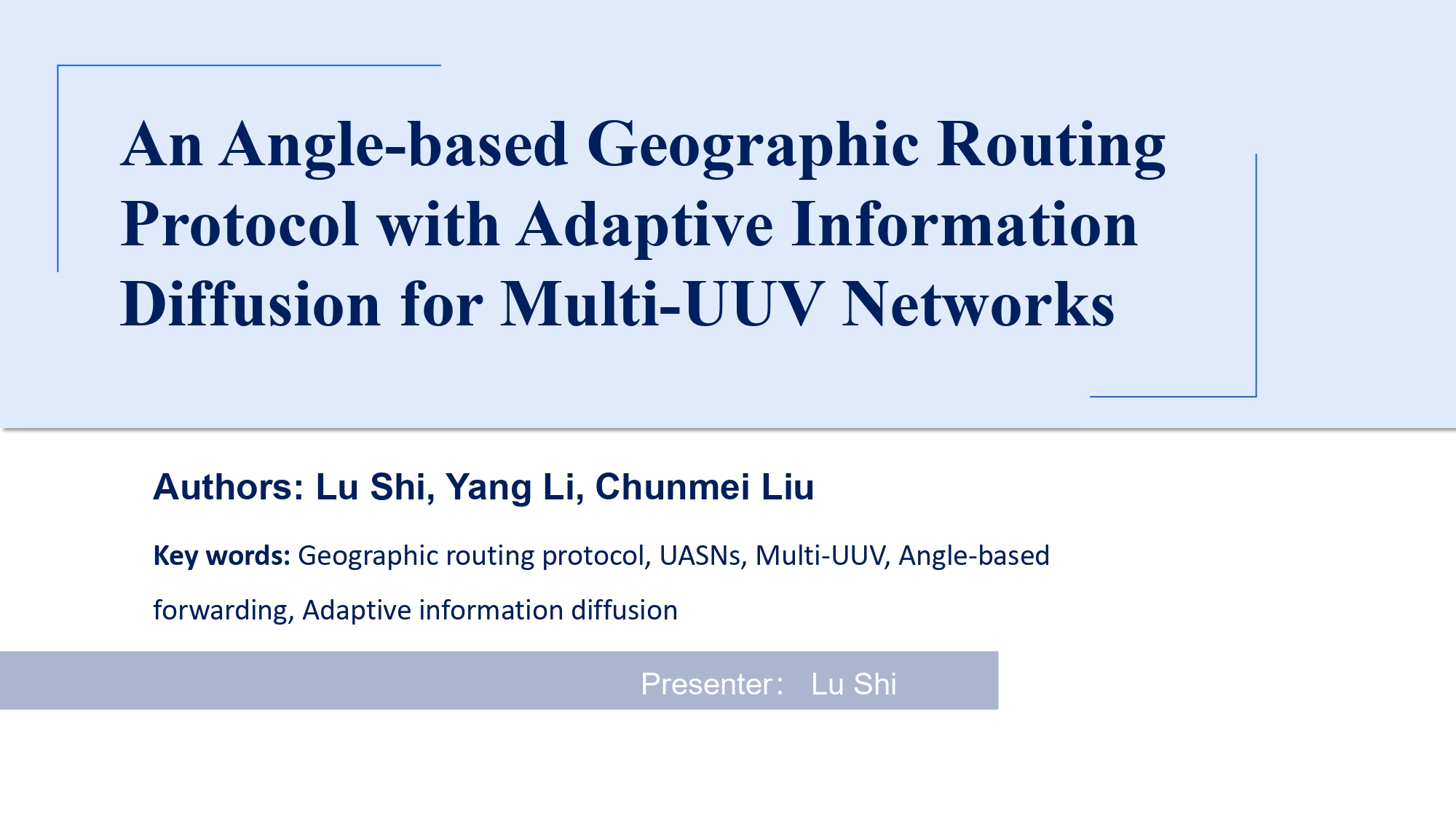 |
Hello everyone, my name is Lu Shi, and I am from the Institute of Acoustics, Chinese Academy of Sciences. Today, I will present our work titled "An Angle-based Geographic Routing Protocol with Adaptive Information Diffusion for Multi-UUV Networks." |
| ICACT20260340 Slide.02
[Big Slide]
[YouTube] |
Chrome Click!! |
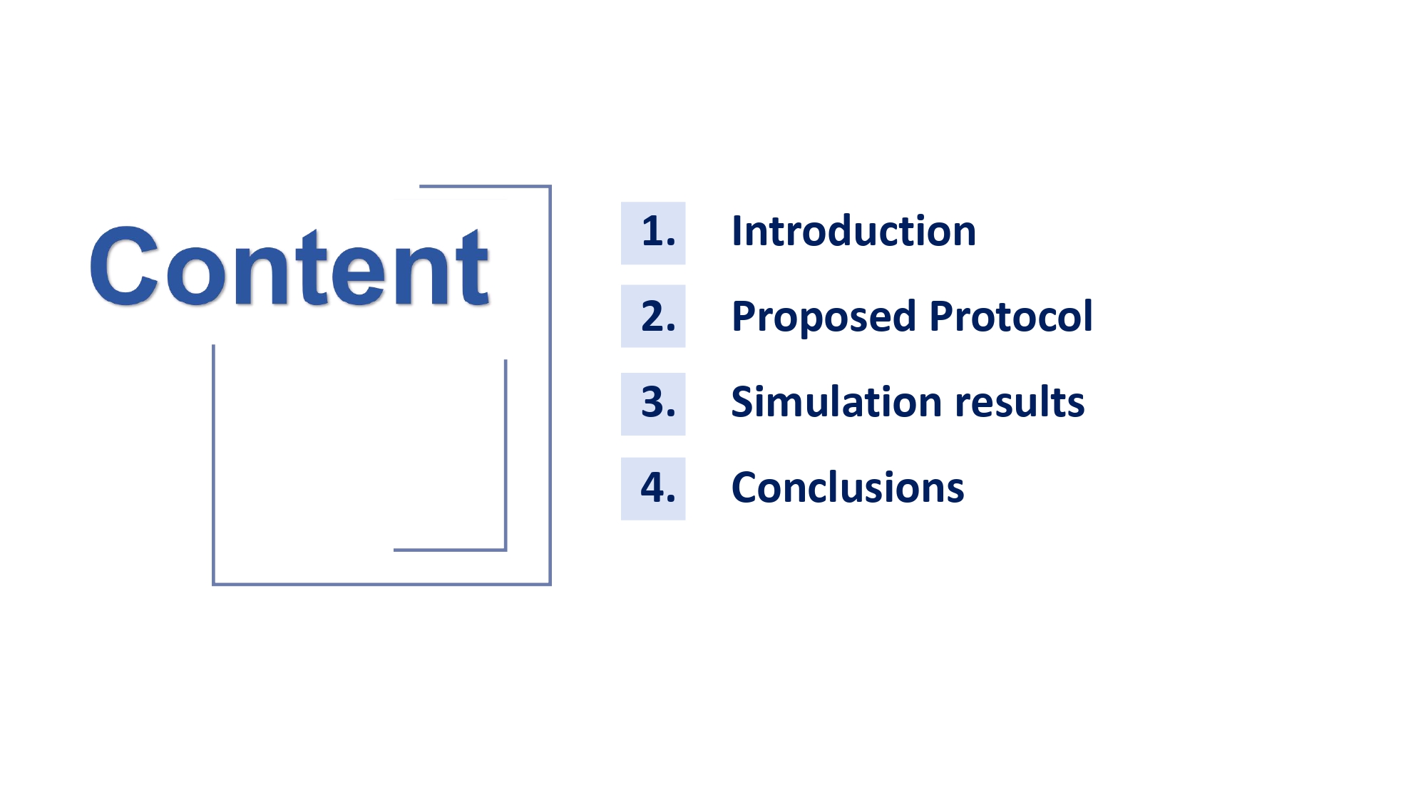 |
My presentation is structured into four parts. First, I will introduce the research background and core problems in multi-UUV networks. Second, I will detail the design of our proposed protocol, APID. Third, I will present simulation results and performance analysis. Finally, I will summarize our findings and discuss future work. |
| ICACT20260340 Slide.03
[Big Slide]
[YouTube] |
Chrome Click!! |
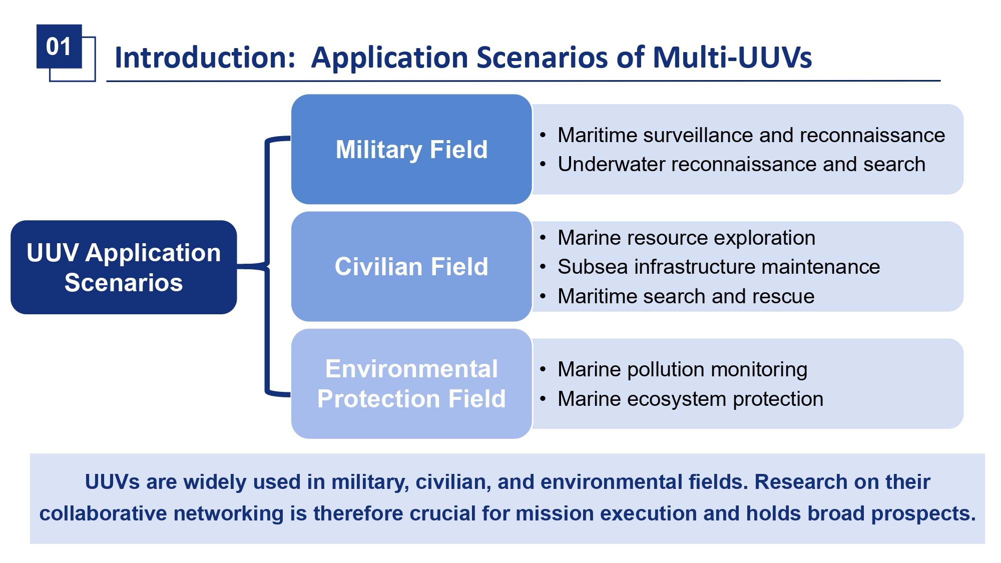 |
Unmanned underwater vehicles, or UUVs, are indispensable tools for underwater missions. They are widely used in military, civilian, and scientific fields for tasks like seabed mapping, pipeline inspection, and environmental monitoring. To accomplish larger-scale, more complex missions, multiple UUVs must collaborate as a coordinated swarm. The foundation of this collaboration is reliable and efficient inter-vehicle communication, which is the focus of our research. |
| ICACT20260340 Slide.04
[Big Slide]
[YouTube] |
Chrome Click!! |
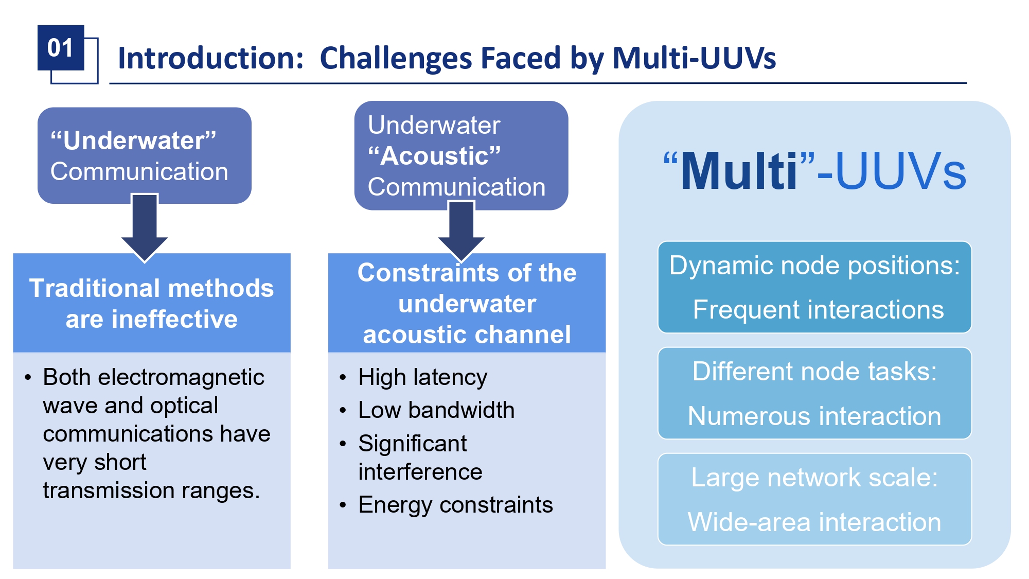 |
Building a communication network for multi-UUV swarms is exceptionally challenging, primarily due to three layers of difficulty.
First, the underwater medium itself is restrictive. Unlike terrestrial networks, radio waves attenuate rapidly in water, leaving acoustic waves as the only viable communication medium.
Second, the underwater acoustic channel is inherently problematic. It is characterized by slow propagation speed, high latency, low bandwidth, and asymmetry. This results in communication links that are naturally unstable and of low quality.
Third, the characteristics of the UUV swarm further complicate the situation. The vehicles are typically battery-powered and energy-constrained. Moreover, they exhibit high and varied mobility patterns while performing tasks, and their movements can be further disturbed by ocean currents. This leads to highly dynamic and unpredictable network topologies.
In summary, we are dealing with a communication medium that is poor, nodes that are resource-limited, and a network topology that is constantly in flux. |
| ICACT20260340 Slide.05
[Big Slide]
[YouTube] |
Chrome Click!! |
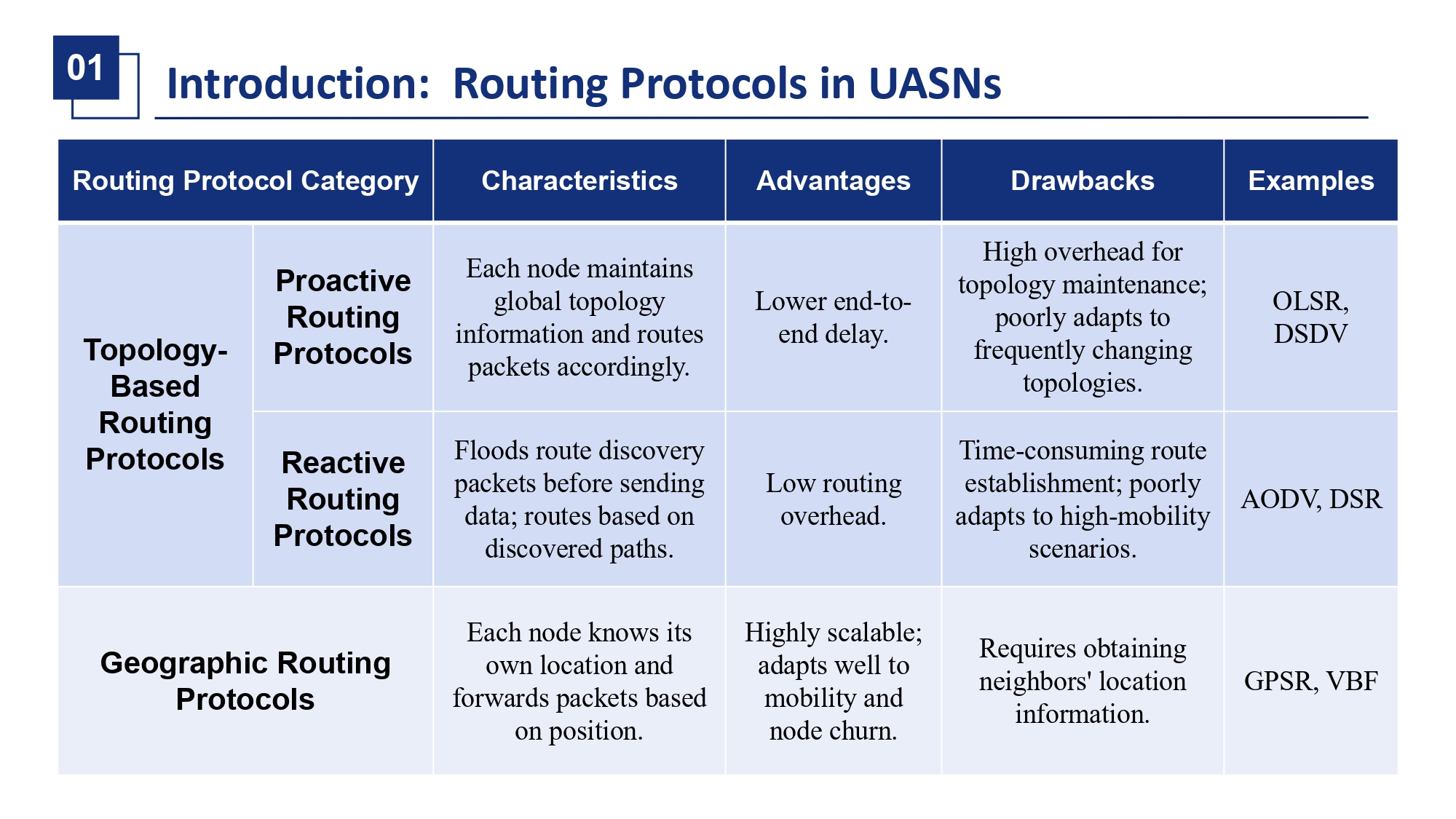 |
Then, lets briefly review existing routing approaches for underwater networks. They are generally classified into three types. Proactive protocols, like OLSR, maintain global routing tables, incurring excessive control overhead in mobile scenarios. Reactive protocols, like AODV, use flooding for route discovery, introducing long delays unsuitable for the slow acoustic medium. Geographic protocols, like GPSR, use location information for forwarding. They have high beaconing overhead to track moving neighbors and overly simplistic next-hop selection, often leading to poor link quality in mobile environments. Clearly, none of these are fully adequate for multi-UUV swarms. |
| ICACT20260340 Slide.06
[Big Slide]
[YouTube] |
Chrome Click!! |
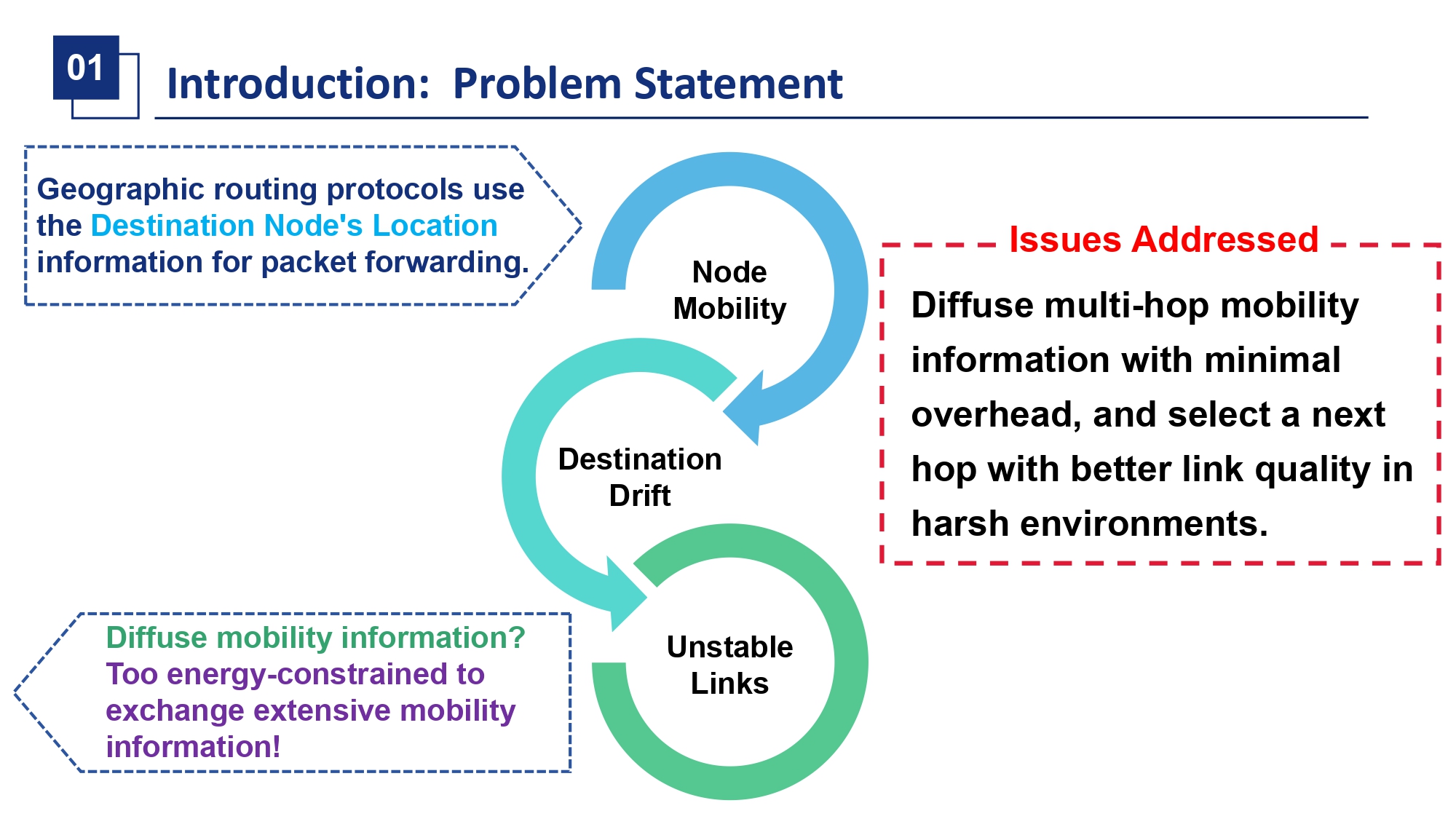 |
Therefore, our work focuses on improving geographic routing. We aim to solve two core problems. First, how can we efficiently diffuse the location updates of a moving destination node across multiple hops with minimal overhead, without flooding the entire network? Second, in a dynamic neighborhood with potentially imperfect location information, how can we select a next-hop forwarder that offers the best balance between geographic progress and link stability? Solving these problems is key to improving packet delivery rate and saving energy. |
| ICACT20260340 Slide.07
[Big Slide]
[YouTube] |
Chrome Click!! |
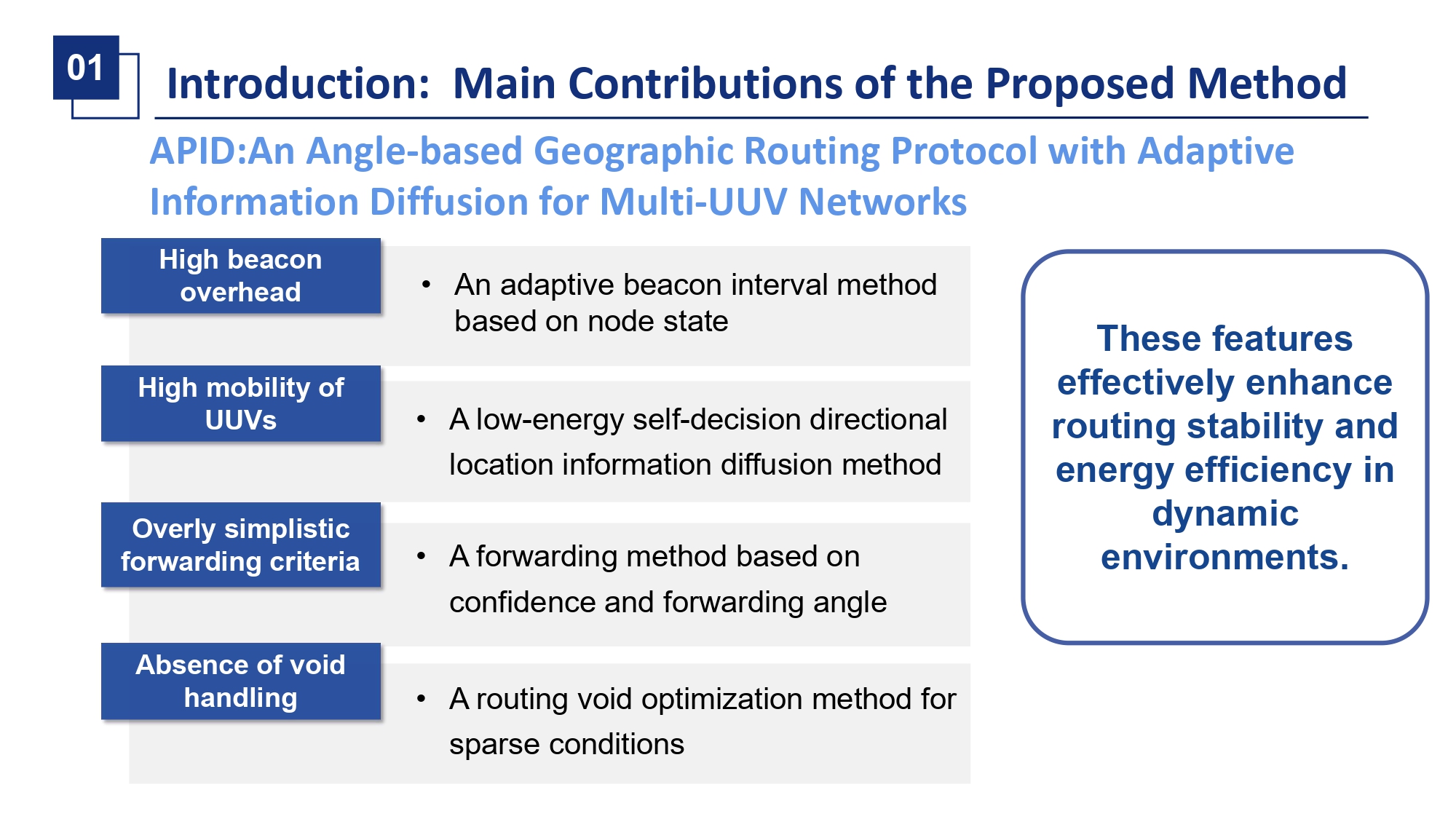 |
To address these problems, we propose APID, which stands for routing protocol with Adaptive Position Information Diffusion and Angle-based forwarding. APID introduces four key mechanisms, each targeting a specific weakness. To reduce beacon overhead, we propose an adaptive beacon interval based on node state. To track mobile destinations, we design a self-decision location information diffusion method. To choose better forwarders, we develop an algorithm based on confidence and forwarding angle. And to handle network voids, we employ a packet buffering mechanism. Together, these features aim to significantly enhance routing stability and energy efficiency. |
| ICACT20260340 Slide.08
[Big Slide]
[YouTube] |
Chrome Click!! |
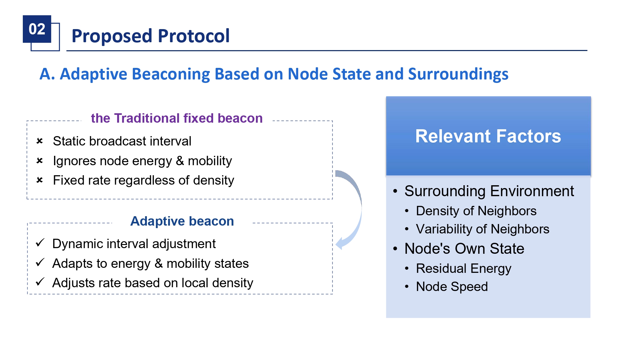 |
First, let me explain the adaptive beaconing mechanism. Traditional geographic routing uses fixed-period beacons, which is inefficient. A stationary or low-energy node does not need to beacon as frequently, while a node in a rapidly changing neighborhood might need to beacon more often. Our method dynamically adjusts the beacon interval based on two factors: the nodes own state and its surrounding environment. |
| ICACT20260340 Slide.09
[Big Slide]
[YouTube] |
Chrome Click!! |
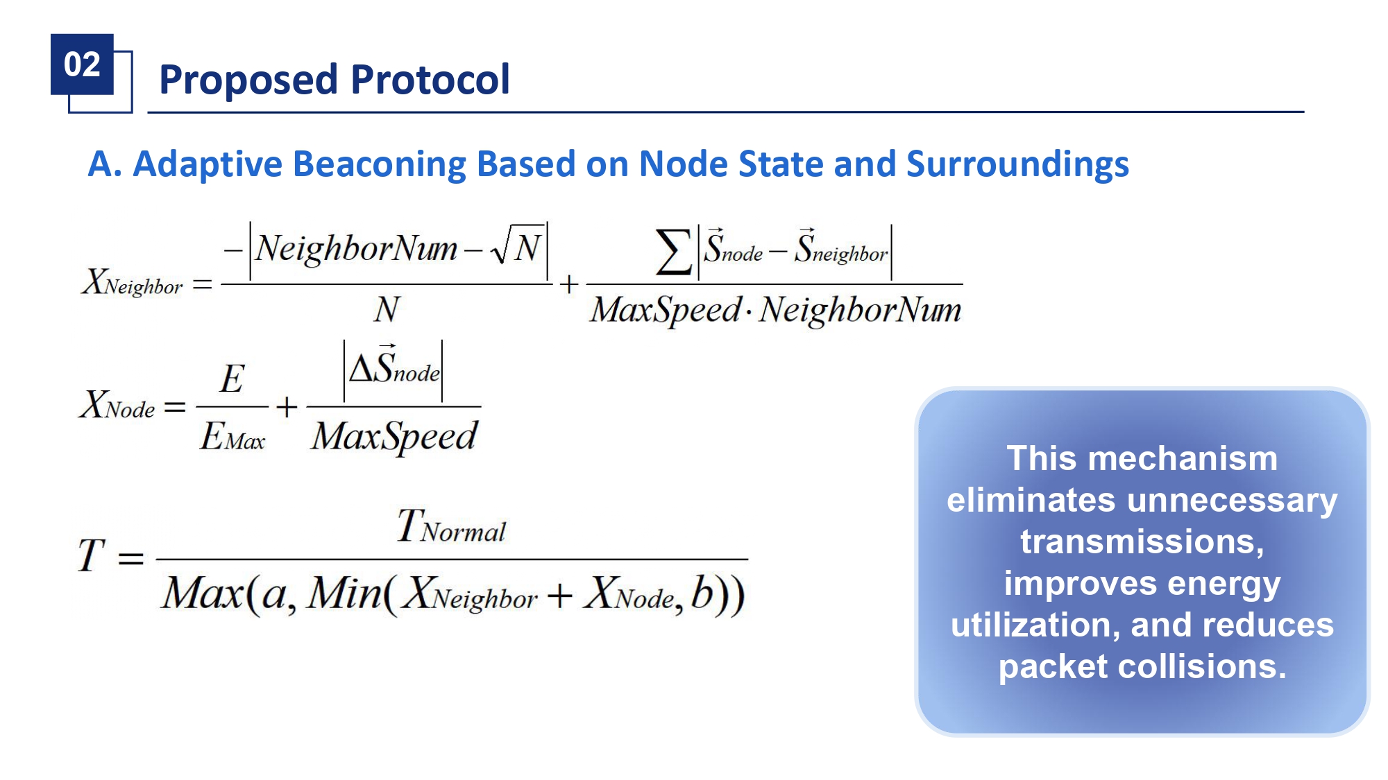 |
Specifically, we calculate two metrics. The neighbor factor, X Neighbor, captures the environment, penalizing deviations from ideal density and incorporating relative speed differences. The node factor, X Node, captures the nodes own condition, favoring higher energy and greater mobility. The final beacon period T is calculate based on X Neighbor and X Node. This means nodes with high energy, high mobility, or in volatile neighborhoods beacon more frequently, while others conserve energy by beaconing less. |
| ICACT20260340 Slide.10
[Big Slide]
[YouTube] |
Chrome Click!! |
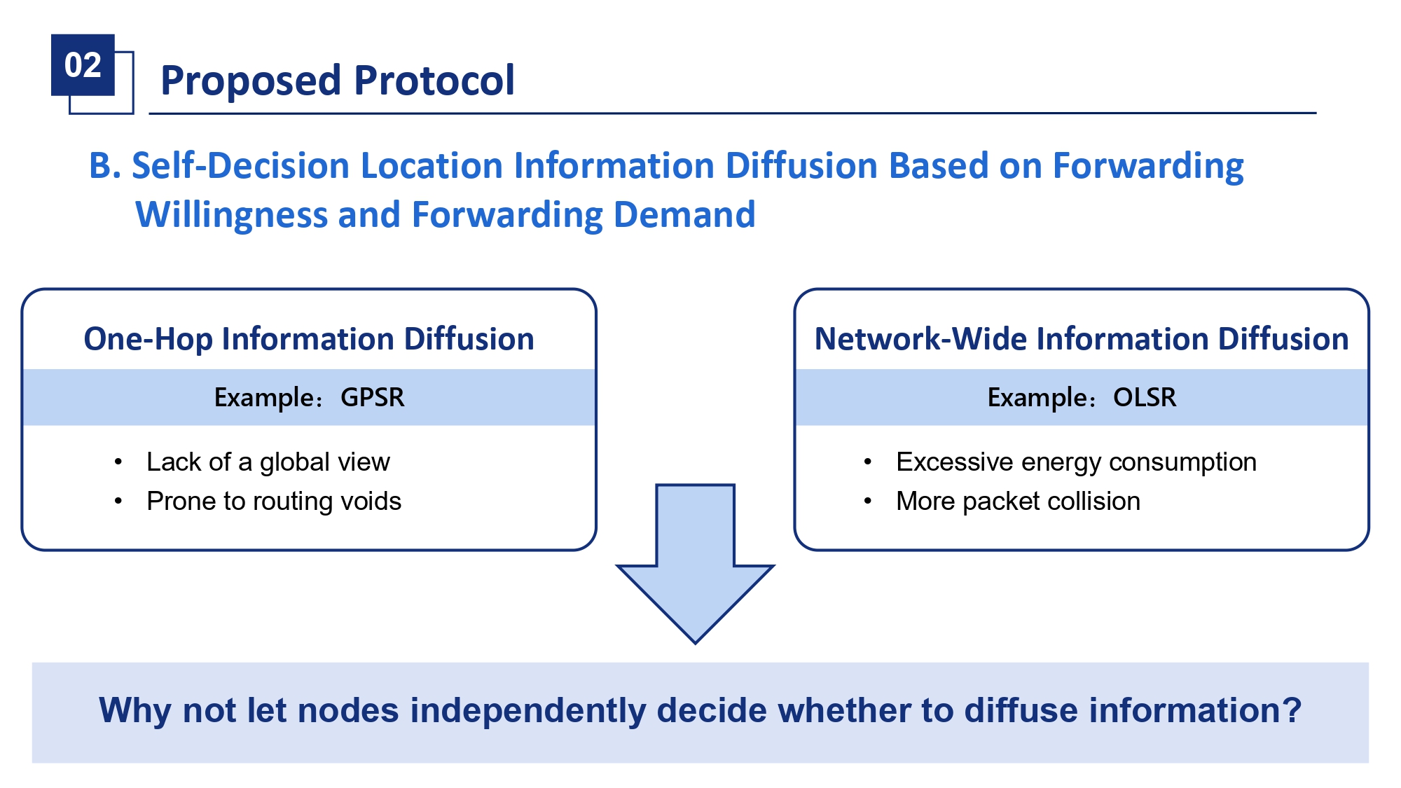 |
Now, onto the second mechanism: information diffusion. When a destination UUV moves, packets in transit might head towards its old location. We need to inform relevant nodes about this move. Simple one-hop beacons, as in GPSR, are insufficient. Network-wide flooding, as in OLSR, is too costly. Our idea is a middle ground: let nodes independently decide whether to forward a location advertisement based on a cost-benefit analysis. The core question is: should this node spend its precious energy to rebroadcast this update? |
| ICACT20260340 Slide.11
[Big Slide]
[YouTube] |
Chrome Click!! |
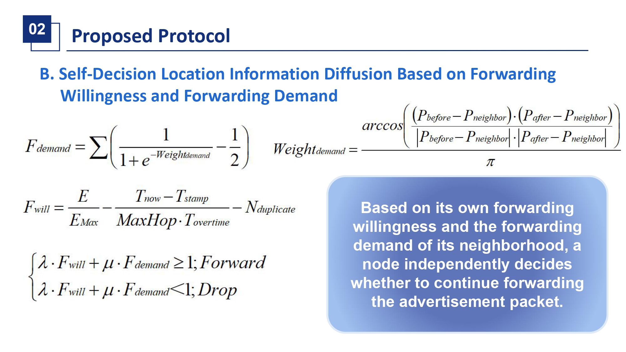 |
This decision is driven by two locally computed values. Forwarding Willingness, F will, is high if the node has high residual energy, the advertisement is very fresh, and it hasnt seen many duplicates. Forwarding Demand, F demand, quantifies how much the nodes own neighbors are affected by the sources movement. Its calculated by measuring the angular change in the sources position relative to each neighbor and aggregating these impacts. A node forwards the advertisement only if a weighted combination of its willingness and its neighbors demand exceeds a threshold. This ensures targeted, demand-driven diffusion. |
| ICACT20260340 Slide.12
[Big Slide]
[YouTube] |
Chrome Click!! |
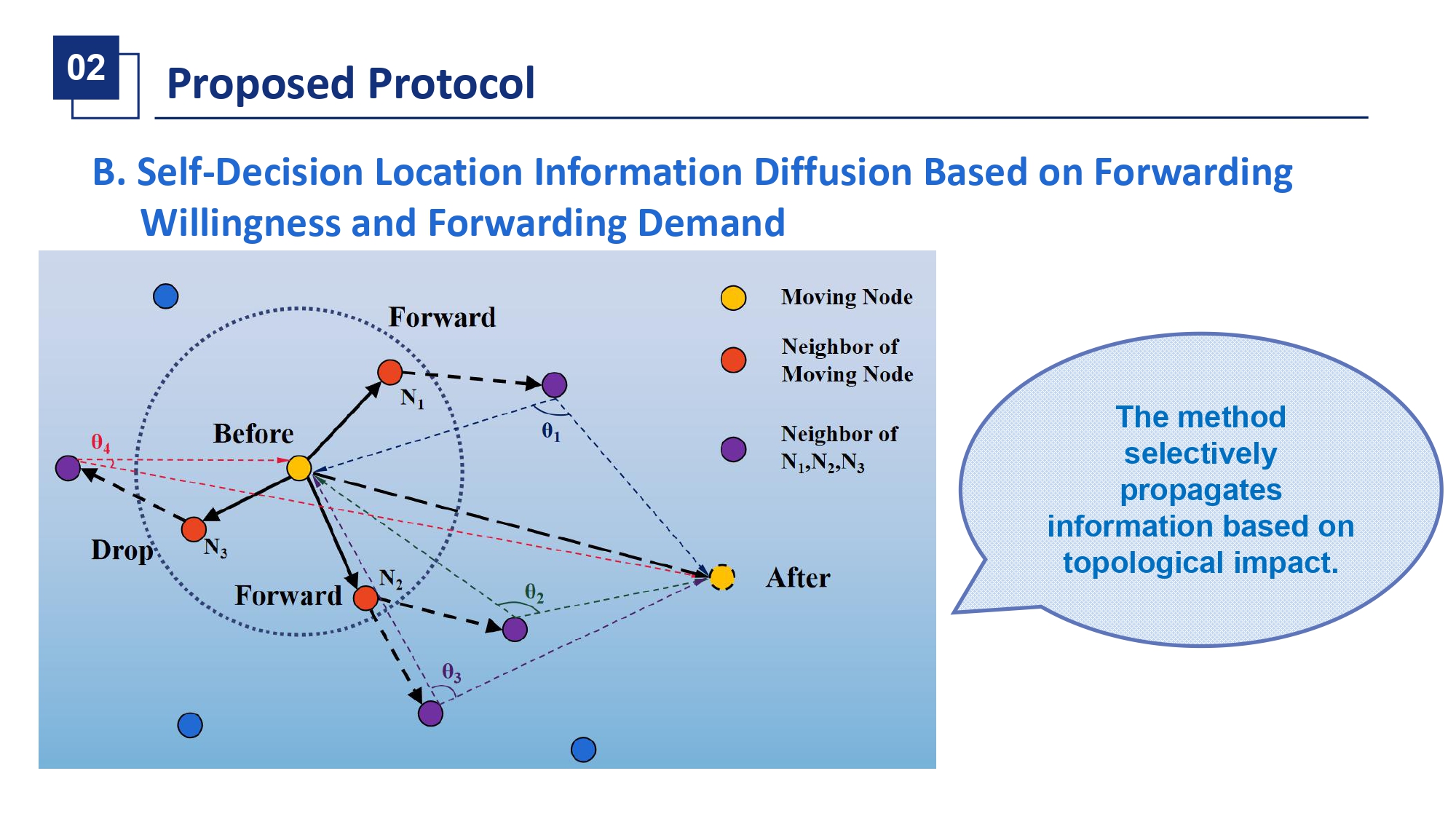 |
This concept is illustrated here. A source node moves and broadcasts an update. Its neighbors, N1, N2, N3, calculate their F will and F demand. N1 and N2, whose own neighbors—like those at angles theta1, theta2, theta3—are highly affected by the move, compute a high F demand. Even with moderate willingness, they decide to forward. N3, whose neighbors—like at theta4—are largely unaffected, has low demand and decides to drop the packet. This selective process efficiently propagates information to areas where it matters most. |
| ICACT20260340 Slide.13
[Big Slide]
[YouTube] |
Chrome Click!! |
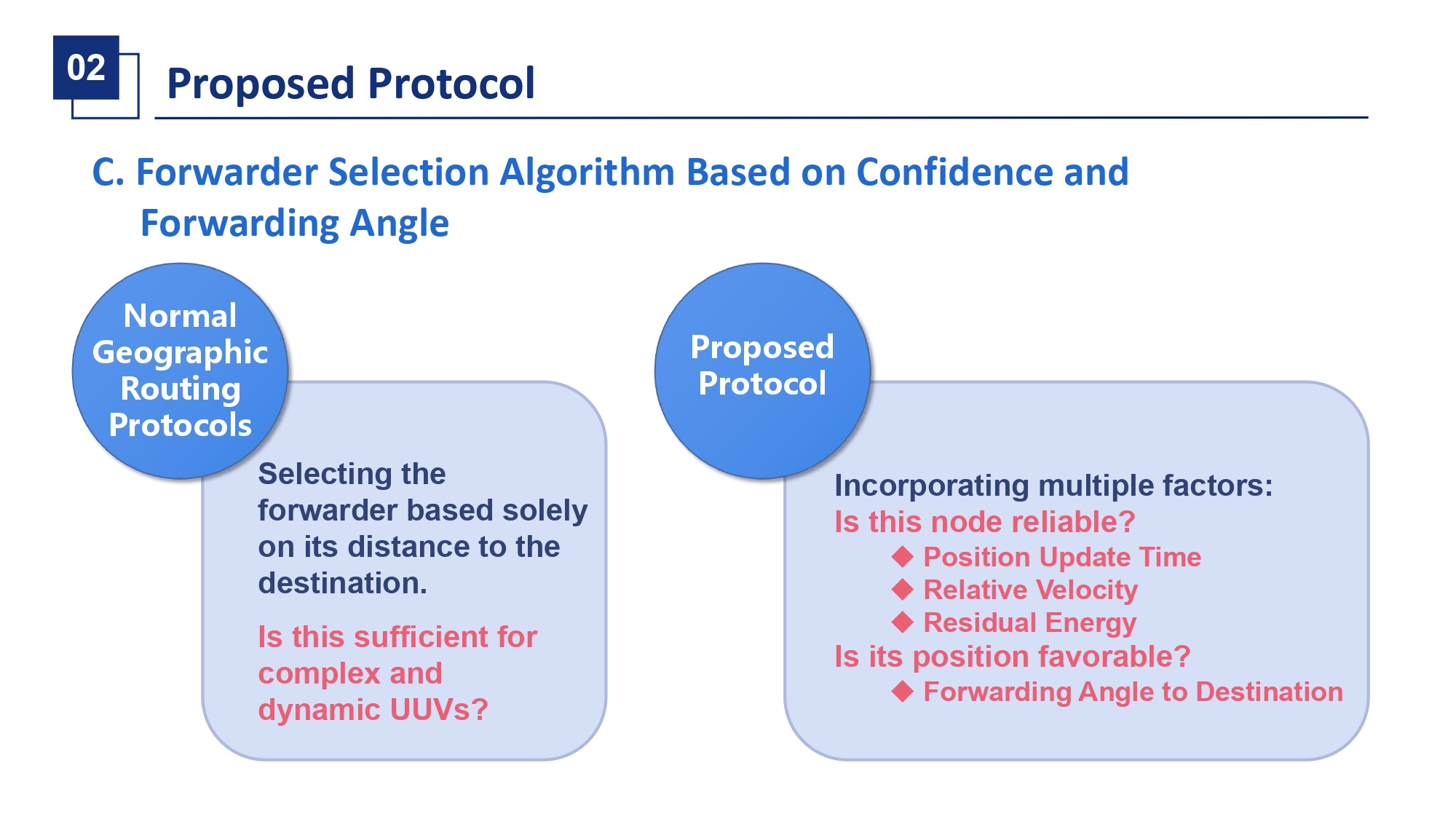 |
The third core mechanism is our forwarder selection algorithm. When a node has a packet to send, it must choose the best next hop from its known neighbors. Traditional GPSR simply picks the neighbor closest to the destination, ignoring link stability. Our method is more sophisticated, using two key concepts: Confidence in a neighbors position and its Forwarding Angle relative to the destination. |
| ICACT20260340 Slide.14
[Big Slide]
[YouTube] |
Chrome Click!! |
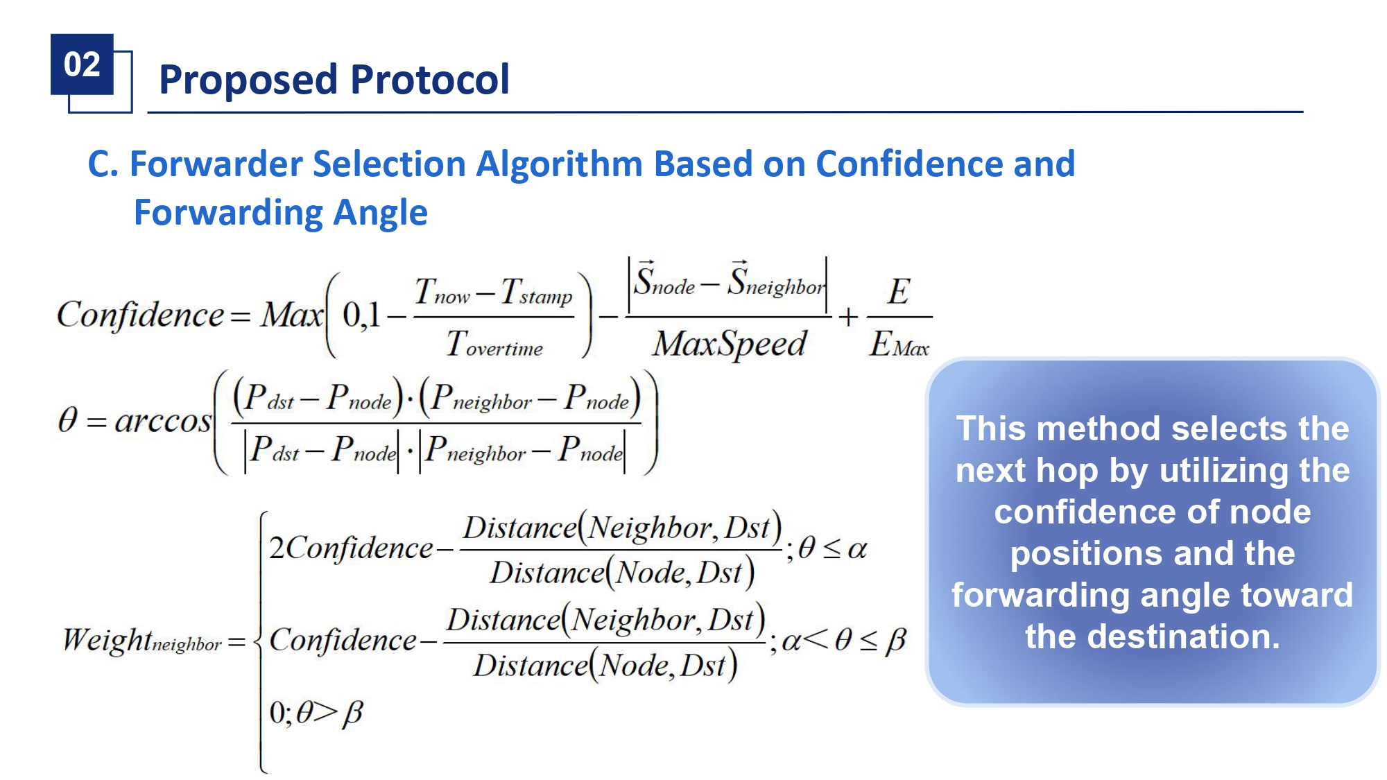 |
Confidence is a metric that reflects how reliable a neighbors location information is. It increases with newer timestamps, lower relative speed between the nodes, and higher neighbor residual energy. The Forwarding Angle theta is the angle between the vector to the destination and the vector to the neighbor. We divide the transmission range into zones: a high-efficiency zone for small theta, a low-efficiency zone, and a non-forwarding zone for large theta. The final weight for a neighbor is a function of its Confidence, its zone, and its remaining distance to the destination. The neighbor with the highest weight is chosen as the next hop. |
| ICACT20260340 Slide.15
[Big Slide]
[YouTube] |
Chrome Click!! |
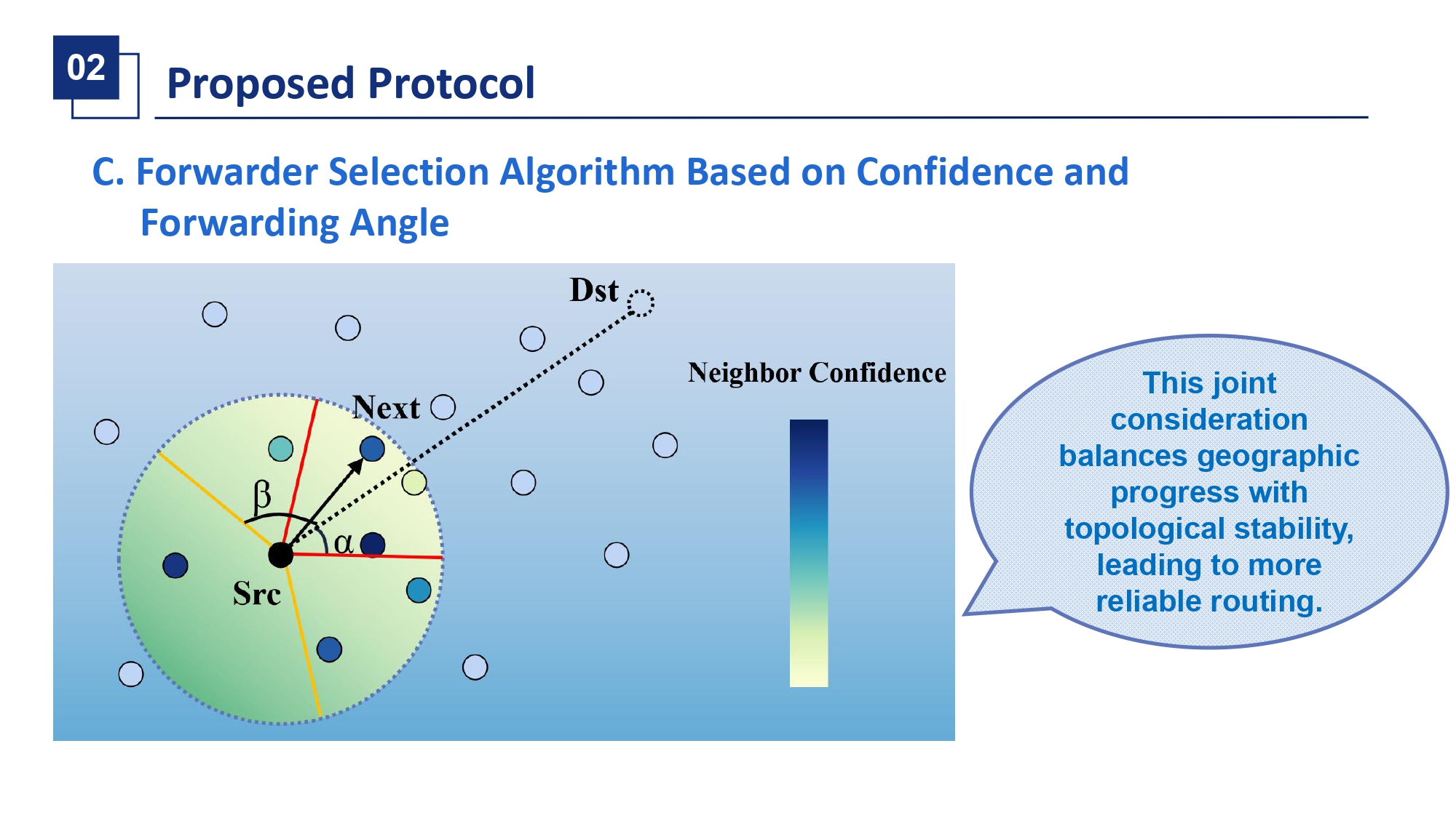 |
This figure visualizes the process. The source node Src looks towards destination Dst. Neighbors are colored by their confidence—darker means higher confidence—and categorized by their angular zone. The algorithm doesnt just pick the closest one. It might favor a slightly farther neighbor in the high-efficiency zone with very high confidence over a closer but unstable one. This joint consideration of geography and link quality leads to more stable multi-hop paths. |
| ICACT20260340 Slide.16
[Big Slide]
[YouTube] |
Chrome Click!! |
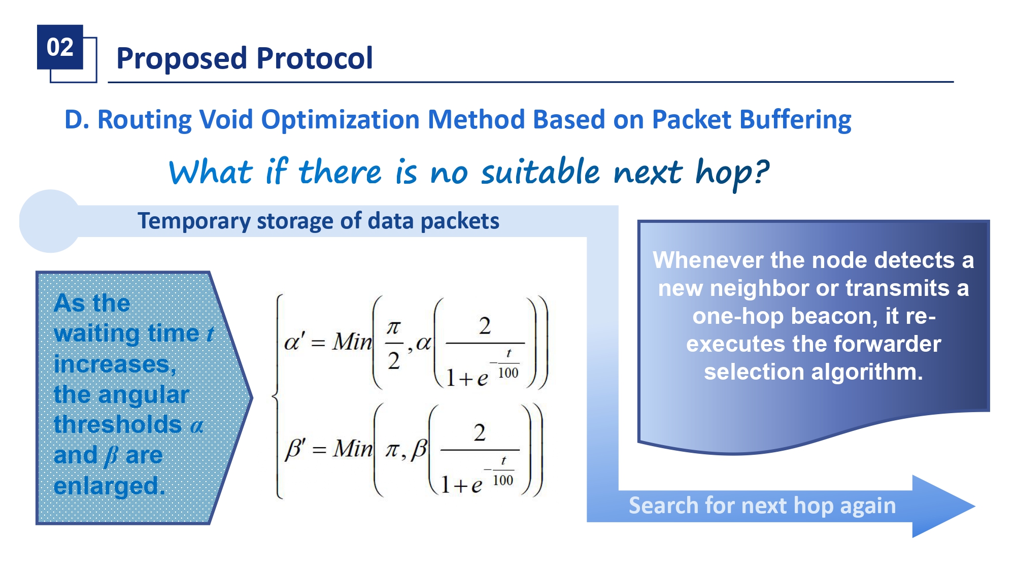 |
Despite the best selection, routing voids can occur where no neighbor meets the criteria. Instead of costly recovery modes, our fourth mechanism uses simple packet buffering. The node stores the packet and waits. Crucially, while waiting, it gradually relaxes its angular constraints—the thresholds alpha and beta increase over time. This expands the forwarding zone, making it more likely that a passing node will qualify. The node re-runs the selection algorithm periodically or when new beacons arrive, forwarding the packet once a suitable neighbor is found. |
| ICACT20260340 Slide.17
[Big Slide]
[YouTube] |
Chrome Click!! |
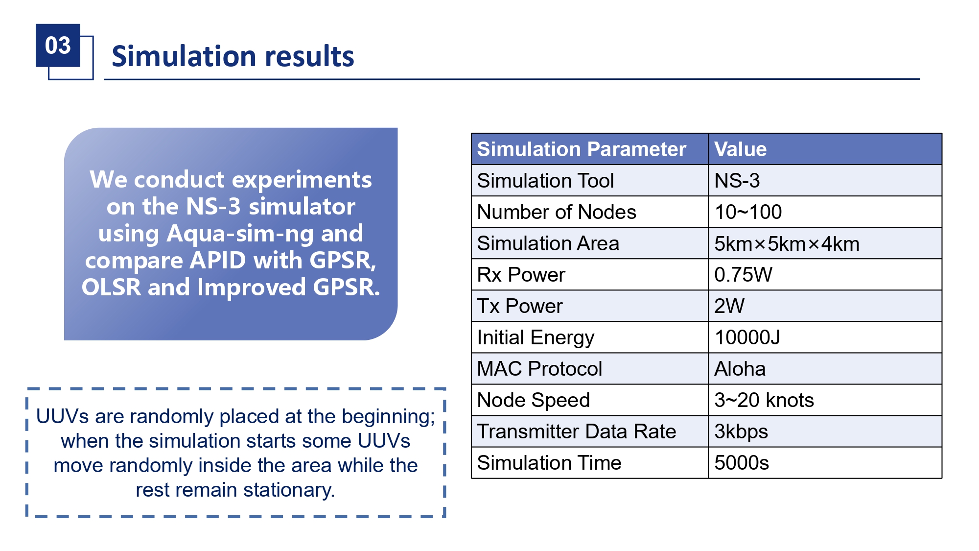 |
We evaluated APIDs performance through extensive simulations on NS-3 with the Aqua-sim-ng underwater module. We compared it against three protocols: the classic GPSR, the proactive OLSR, and an Improved GPSR that maintains a two-hop neighbor table. In our scenario, UUVs were randomly deployed in a 5km by 5km by 4km volume. A fraction of them moved randomly while others were stationary. Key parameters are listed here. |
| ICACT20260340 Slide.18
[Big Slide]
[YouTube] |
Chrome Click!! |
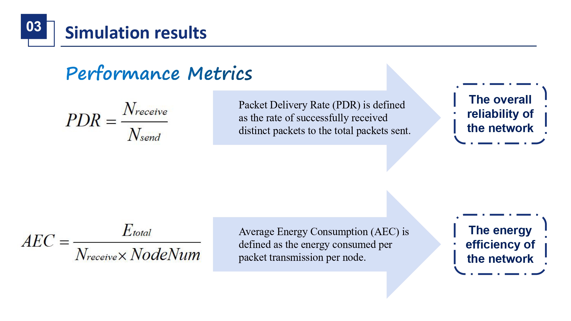 |
We used two primary metrics for evaluation. Packet Delivery Rate, or PDR, the ratio of packets successfully delivered, measures network reliability. Average Energy Consumption, or AEC, the total energy used divided by the number of delivered packets and nodes, measures energy efficiency. |
| ICACT20260340 Slide.19
[Big Slide]
[YouTube] |
Chrome Click!! |
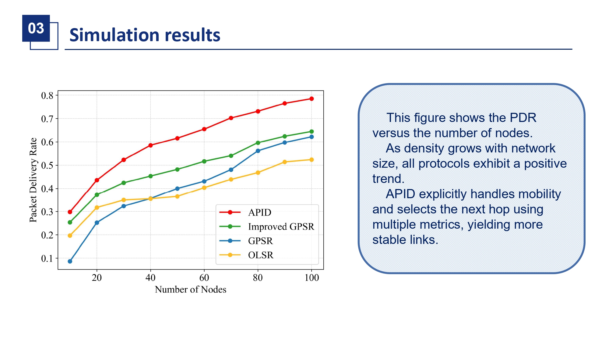 |
Lets look at the results. First, PDR versus the number of nodes. As node density increases, all protocols improve, but APID consistently outperforms all others. Specifically, compared to GPSR, Improved GPSR, and OLSR, APID raises PDR by forty-eight percent, twenty-four percent, and fifty-five percent respectively at the scale shown. This is because APIDs multi-metric forwarder selection establishes more stable links, and its adaptive mechanisms work well across different densities. |
| ICACT20260340 Slide.20
[Big Slide]
[YouTube] |
Chrome Click!! |
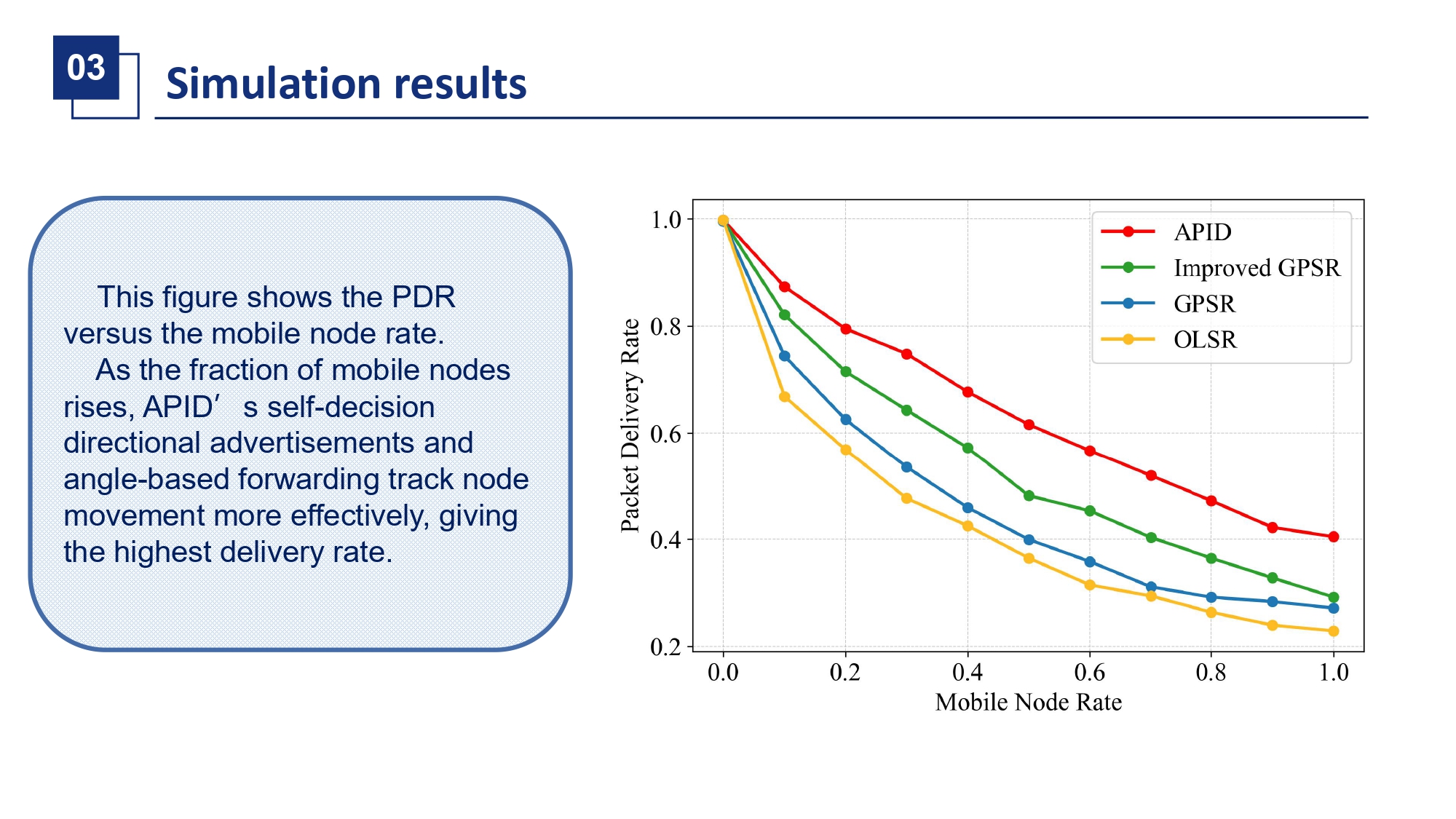 |
Then, PDR versus the fraction of mobile nodes. When all nodes are static, all protocols do well. But as mobility increases, OLSRs performance drops sharply due to outdated routes. GPSR also declines. Improved GPSR handles mobility better than GPSR. However, APID maintains the highest delivery rate, surpassing GPSR by thirty-three percent on average. This demonstrates the effectiveness of our self-decision location diffusion in tracking mobile destinations and our angle-based forwarding in choosing stable next-hops amidst movement. |
| ICACT20260340 Slide.21
[Big Slide]
[YouTube] |
Chrome Click!! |
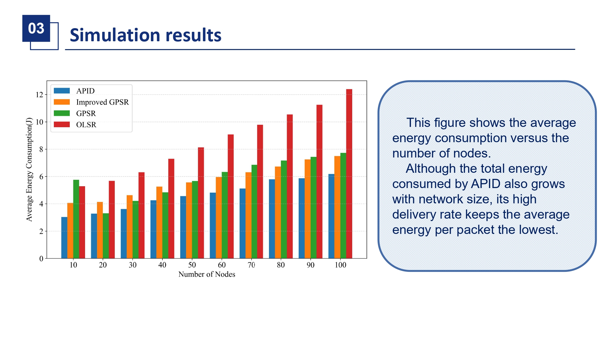 |
Finally, energy efficiency. This graph shows Average Energy Consumption versus node count. While total energy use grows for all protocols, APIDs high delivery rate means the energy cost per successfully delivered packet is the lowest. Compared to GPSR, Improved GPSR, and OLSR, APID reduces AEC by twenty-one percent, eighteen percent, and a remarkable forty-five percent. This proves that our adaptive beaconing and targeted information diffusion successfully save energy without compromising delivery performance. |
| ICACT20260340 Slide.22
[Big Slide]
[YouTube] |
Chrome Click!! |
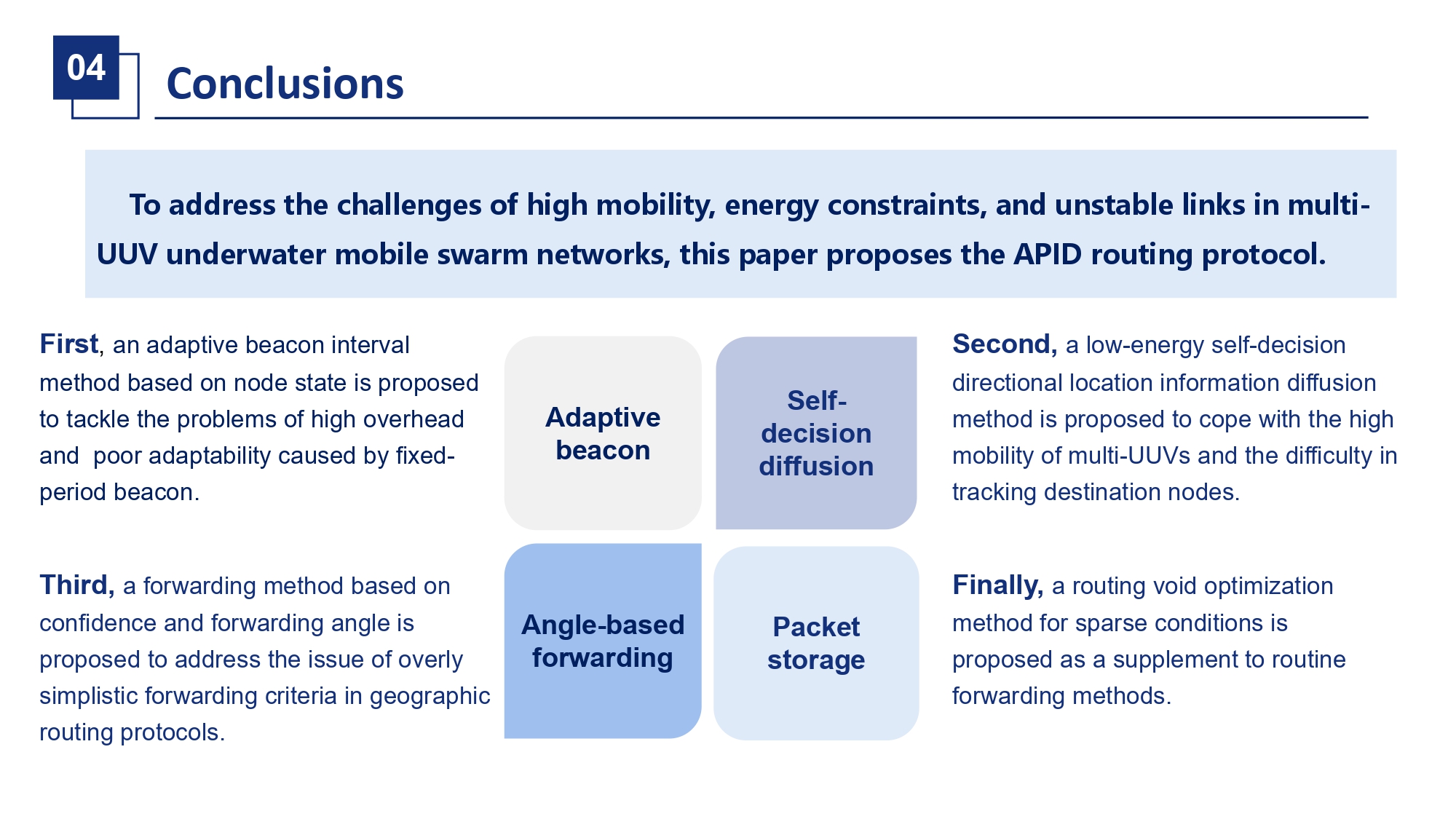 |
In conclusion, to address the critical challenges of mobility, energy, and unstable links in multi-UUV networks, we have proposed the APID routing protocol. Its core innovations are: an adaptive beacon interval, a demand-driven location information diffusion strategy, a confidence and angle-based forwarder selection algorithm, and a void-handling packet buffer. Simulation results confirm that APID significantly improves packet delivery rate and reduces average energy consumption compared to existing protocols, making it a highly suitable solution for underwater mobile swarms. |
| ICACT20260340 Slide.23
[Big Slide]
[YouTube] |
Chrome Click!! |
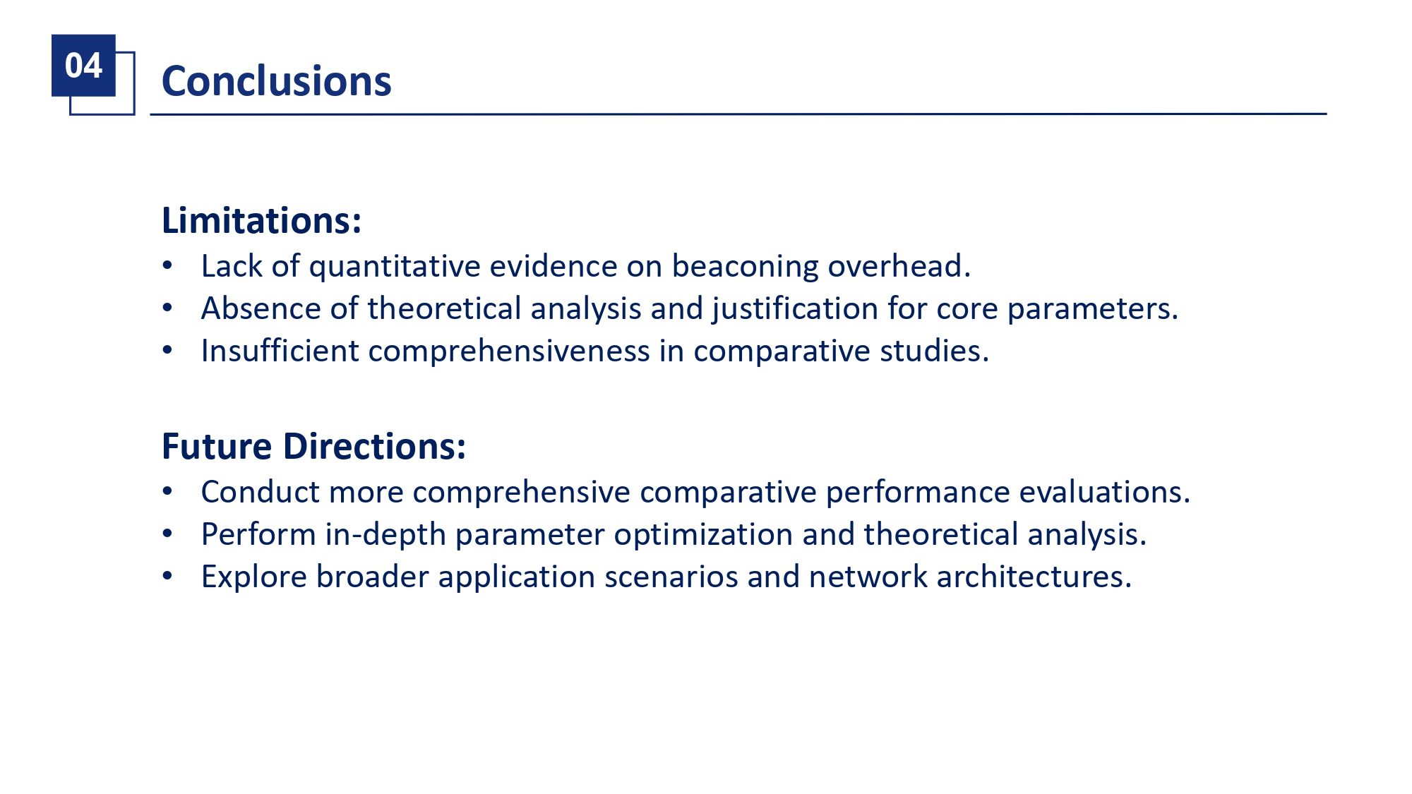 |
Of course, our work has limitations. We currently lack a theoretical analysis for parameter optimization, and our comparative study, while comprehensive, could be expanded. For future work, we plan to conduct more in-depth parameter sensitivity studies, derive theoretical bounds, and explore APIDs applicability in even more dynamic scenarios and heterogeneous network architectures. |
| ICACT20260340 Slide.24
[Big Slide]
[YouTube] |
Chrome Click!! |
 |
Thank you for your attention. I am now happy to take any questions you may have. |
| |